Image Map

Definition
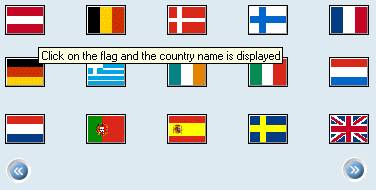
This control contains clickable areas which are associated with an image. The id of the imageMap is associated with the image control (using the 'setImageMap' method). The imageMap control contains imageAreas. The imageAreas contain links which define the links or event handling methods that have to be processed when the imageArea has been clicked.
· id
Identification name of the imageMap.
Attributes |
M |
Values |
Usage |
id |
* |
String (cs) |
Taglib Classlib |
Control API for Image Area (imageArea)
This control is used to define the clickable areas. The areas can be polygons, rectangles and circles. The areas are defined in coordinates. The origin of the coordinates is the upper, left corner of the image.
· areaType
Defines the shape of the area:
¡ CIRCLE
Circular area. The circle is defined by the center and the radius of the circle.
Example (from top=100, from left=200, radius=30): 100,200,30
¡ POLYGON
The polygon is defined by coordinates of the polygon points.
Example: Triangle (p1=100,100, p2=0,200, p3=200,200): 100,100,0,200,200,200,100,100
¡ RECTANGLE
Rectangular area. The rectangle is defined by the upper left and lower right corner.
Example (Upper Left= 100,100, Lower Right=300,200): 100,100,300,200
· coordinates
Defines the coordinates of the area according to the areaType. The coordinates are separated by commas.
· link
Id of the link control that is associated with the imageArea. The link defines the action (link or event) which is performed when the user clicks on this area.
· tooltip
Defines the hint of the imageArea which is displayed as the mouse cursor passes over the imageArea, or as the mouse button is pressed but not released.
Attributes |
M |
Values |
Usage |
areaType |
|
CIRCLE |
Taglib Classlib (See hint below) |
coordinates |
|
String |
Taglib Classlib (See hint below) |
link |
|
String (cs) |
Taglib Classlib |
tooltip |
|
String |
Taglib Classlib |

When you use the classlib, the areaType and the coordinates have to specified already when the imageArea is created.
Example:
ImageArea circ_left = new
ImageArea
(com.sap.htmlb.enum.ImageAreaType.CIRCLE,
"12,165,12");
Example
using the taglib
<hbj:link |
using the classlib
see imageMap example in the PDK |
Result (from classlib example)