Mapping Geo-Relevant Characteristics
In order to be able to display geographical BW data, a connection between this data and the respective geographical characteristics must be established. This process is described as Mapping Geo-Relevant Characteristics.
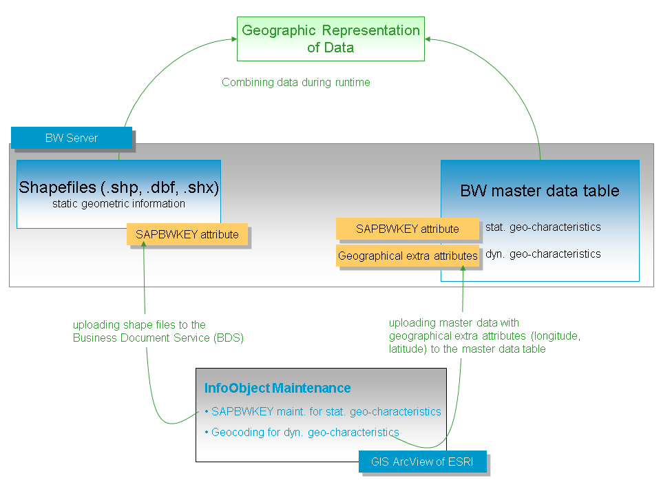
The geographical information about geographical boundaries of areas that are displayed using static geo-characteristics is stored in Shapefiles. In the shapefile, a BW-specific attribute called the SAPBWKEY is responsible for connecting an area on the map with the corresponding characteristic value in BW. This attribute matches the characteristic value in the corresponding BW master data table. This process is called SAPBWKEY Maintenance for Static Geo-Characteristics. See SAPBWKEY Maintenance for Static Geo-Characteristics
You can use ArcView GIS or other software that has functions for editing dBase files to carry out the SAPBWKEY maintenance (MS Excel, for example).
With data in point form that is displayed using dynamic geo-characteristics, geographical data is added to BW master data. The process of assigning geographical data to entries in the master data table is called geocoding. See Geocoding
The software ArcView GIS from ESRI (Environmental Systems Research Institute) geocodes the InfoObjects.
You can execute the geocoding with the help of the ArcView GIS from ESRI software. As well as geocoding, ArcView also offers a large number of functions for special, geographical problems that are not covered by SAP NetWeaver Business Intelligence. With ArcView, you can create your own maps, for example, a map of your sales regions. You can find more detailed information about this in the ArcView documentation.
When you buy SAP NetWeaver BW, you receive a voucher that you can use to order ArcView GIS from ESRI.
The scope of supply also contains a CD developed specially by SAP and ESRI. The CD contains a range of maps covering the whole world in various levels of detail. All maps on this data CD are already optimized for use with SAP NetWeaver BW. The .dbf files for the maps already contain the column SAPBWKEY that is predefined with default values. For example, the world map (cntry200) in the column SAPBWKEY already contains the typical values in SAP systems for countries. You can immediately use this map to geographically evaluate your data; no SAPBWKEY maintenance is necessary.
You can get additional detailed maps in ESRI Shapefile format from ESRI.